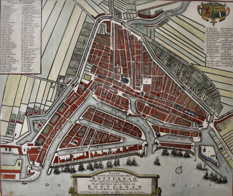
Map of ROTTERDAM by Henry de Leth . J. Covens & Zoon 1768. Antique Copper Engraving.
Make an inquiry
Original antique copper engraving, hand coloured with the map of Rotterdam.
NIEUWE PLATTE GROND VANDE STAD ROTTERDAM Geleegen aande Rivieren de Maase en de Rotte. / PLAN NOUVEAU DE LA VILLE DE ROTTERDAM Située sur les Rivieres de la Meuse et de la Rotte.
Title in Dutch & French in a stone under in the engraving with a scalebar of 50 Schiedamse Roeden.
Top left a leganda with 76 aanwijzingen der voornaamste straten gebouwen (Streets & Buildings) and top right in cartouche the cat of arms of the state Holland and on the right of the city Rotterdam. where under legenda 79 - 111 & Dit plan verbetert en accuraat nagesien, 1768 te Amsterdam by J. COVENS & ZOON.
First issue of this rare big map was in 1733 by Hendrik de Leth in Amsterdam.
This is a later publishing from 1768, renewed by Covens & Zoon in Amsterdam.
Height: 40,5 cm. (16 inches.)
Width: 48 cm. (18,9 inches.)
- Reference
- WP.015
- Price
- € 750
- Share


